
Surveyors face a variety of challenges with land assessment. Limited accessibility, topography changes, weather events, and poor visibility can make surveying a difficult and time-consuming task.
To streamline surveying, many industry professionals are turning to unmanned aerial vehicles (UAVs)—also known as drones. Luckily, recent advancements in UAV technology make the process of surveying easier and more accessible than ever.
As drones become cheaper and more robust, they can provide many benefits for professional land surveyors. As such, it’s critical to have a working knowledge of drones, given how useful they’ve become—and will continue to be going forward.
What Is Drone Surveying?
Just as the name suggests, drone surveying involves using a drone to capture aerial data about various geographies and landscapes.
During a drone survey, the pilot sets up near a survey site and deploys a UAV. Once it’s in the air, the pilot flies the drone over the plot of land and captures data using sensors like multispectral and RGB cameras.
Due to its versatility and ease of use, drone surveying is a flexible and affordable way to expand your data collection efforts and improve the way you survey land.
Due to its versatility and ease of use, drone surveying is a flexible and affordable way to expand your data collection efforts and improve the way you survey land
Drone Surveying Deliverables
Drones can create a variety of assets, such as elevation models, 3D land models, and orthomosaics, among other things. Using this information, operators can gain highly accurate and informative land assessments, leading to better reporting and intelligent decision-making for private and public land development and conservation projects.
Drone operators are able to capture data that can yield the following deliverables.
Photos and Videos
Drones often utilize high-definition photo and video cameras to capture the most basic assessments that you can collect via drone. They often prove useful when conducting preliminary research or ongoing site assessments.
3D Models
In addition to traditional photos and videos, drones can also produce 3D surface models for highly advanced and detailed topographic mapping.
Using drones, you can create 3D models by collecting ground points. Once you have the ground points, you can run them through modeling software and assemble a 3D point cloud, or a collection of data points in space.
Orthophotos
An orthophoto is a type of aerial photograph that utilizes geographical correction, enabling images with a uniform scale.
Orthophotos help measure the true distance between points. Additionally, orthophotos take several factors into account, adjusting for aspects such as lens distortion and topographic relief along the way.
What Are the Benefits of Drone Surveying?
Using drones for surveying purposes can seem like a major change if you typically rely on tools like composite tripods, locators, column pods, and rover rods for surveying work. And in some ways, this new and modern approach can take some getting used to.
Yet while drone surveying may seem intimidating at first, it’s ultimately just another tool that you can use to work smarter and more efficiently—remaining competitive while boosting your bottom line.
There are several enticing benefits to using drones for geographical data collection, which we’ll examine next.
Low Altitude Flying
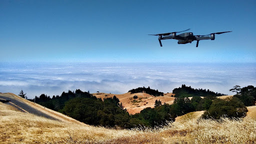
Thanks to drones, surveyors no longer have to resort to using satellites, crewed aircraft, and balloons to collect aerial data. Drones can fly at much lower altitudes, helping capture data with far greater control and precision.
Drones can also fly into areas that would otherwise be very difficult or impossible to capture using traditional aerial vehicles. This includes highly heavily forested or mountainous areas and dense urban environments that aren’t suitable for helicopters or airplanes.
Drones can also fly into areas that would otherwise be very difficult or impossible to capture using traditional aerial vehicles
Comprehensive Imaging
Drones can also capture multiple images of the same ground location from several different angles and elevations. It’s possible to use this data to provide a detailed overview of a geographic area, letting you see properties from different perspectives and angles.
When surveying land, teams often deploy several drones at a given time to make the process easier. By using more than one drone, you can take images faster and more efficiently, covering more space along the way.
Ongoing Analysis
Geographic topography can change significantly over time, making it challenging to keep track of land borders. In some cases, changes can be gradual. Rivers or streams often change course, trees disappear, and property lines shift. Topography can also change overnight due to new construction and weather events.
With the use of drones, you can conduct ongoing land surveys at periodic intervals. This can enable improved historic reporting as well as rapid response surveying.
Sustainability Support
Using drones can help boost sustainability efforts. They emit lower emissions during inspections compared to cars, trucks, helicopters, and aircraft.
In addition, drones can help reach key environmental areas that are hard to access, including forests, coastal areas, and population centers. They can also help provide ongoing assessments to study conservation efforts and climate change.
Improved Productivity
Traditional land surveying methods are highly time-intensive, restricting the number of jobs that surveyors can do during the day. But with the help of one or more drones, you can cover more ground at a faster pace—quickly analyzing entire neighborhoods and large bodies of land.
Drone Surveying Best Practices
Drone surveying is an exciting emerging technology and is completely legal under the Federal Aviation Administration (FAA).
That said, there are some important rules and regulations to be aware of before you rush out and buy a drone and fly it for the first time. For the best results, follow these best practices to avoid any potential mishaps.
Shop Around for Drone Insurance
The FAA requires you to have full insurance for any commercial drone purposes. As such, it’s important to shop around for an insurance plan that meets your needs.
Drone coverage typically costs anywhere from $500 to $750 per year or more. Some popular options for drone insurance include the United States Aircraft Insurance Group (USAIG) and BWI Fly.
Make Sure You Have an FAA License
In addition to having insurance, pilots must also receive an official Remote Pilot Certificate from the FAA. The FAA provides a complete breakdown of what you need to obtain a Remote Pilot Certificate.
Follow FAA Restrictions
The FAA has specific requirements governing the type of drone you can operate, and what you can do with it. For example, small drones weighing under 55 pounds are acceptable for business use under the FAA’s Part 107 guidelines. Anything weighing more than 55 pounds requires special permission.
Further, drones can’t fly higher than 400 feet when surveying land in the US. And if you want to fly after dark, you’ll need a special license.
It’s also important to stay within acceptable airspace—especially when capturing camera footage. Flying over private property or filming it is trespassing and could lead to civil penalties and fines.
Consider Going Beyond Visual Line of Sight (BVLOS)
When surveying land with a drone, the device must always stay within the visual line of sight of the pilot. In other words, the drone can’t fly behind a building, bridge, or mountain. Unfortunately, this can be very restricting depending on the job.
When a drone disappears from the pilot’s line of sight, it becomes a beyond visual line of sight (BVLOS) operation and requires specific technologies, such as an onboard detect-and-avoid component. Flying BVLOS also requires special approval from the FAA.
How Iris Automation Can Help
Iris Automation is leading the UAV industry in producing cutting-edge BVLOS technologies. With the help of Iris Automation, your business can enable BVLOS deployments and expand your surveying operations across wider distances—increasing productivity and safety while lowering surveying costs.
To learn more about Iris Automation’s approach to BVLOS, check out our use cases.
This post was written by Justin Reynolds. Justin is a freelance writer who enjoys telling stories about how technology, science, and creativity can help workers be more productive. In his spare time, he likes seeing or playing live music, hiking, and traveling.